Wind and weather for Kitesurfing
our forecast
live weather
chart for the past hours
Kitesurfing on Lake Silvaplana is generally only possible with south to south-west winds. The mandatory entries and exits (see zone plan) also only work in southerly winds. Northerly winds are very rarely rideable and only professionals should attempt it, if at all.
Whether there is good wind for kitesurfing on Lake Silvaplana depends on the following factors:
- Pressure distribution / air flow over the Alps
If the current is south or west, it supports the dominance of the thermal Maloja wind. If the current is north to south-east, it hinders the thermals, which then arise later or do not penetrate until Silvaplana. - Weather in Silvaplana and Bergell
Unobstructed sunlight quickly heats up the slopes and rock slabs, creating strong, reliable thermals. Clouds slow down warming. - Temperatures in Silvaplana and Bergell
A thermal is stronger the stronger the atmospheric temperature gradient is, i.e. the stronger the temperature decreases per unit of altitude.
here you get to the snowkiting weather information
The meeting point for the courses is always at the agreed time. Forecasts can also be wrong!
We refuse any liability regarding weather and stick to the slogan "There is always wind". If there is no wind you do not have to pay any rent or lessons (except theory).
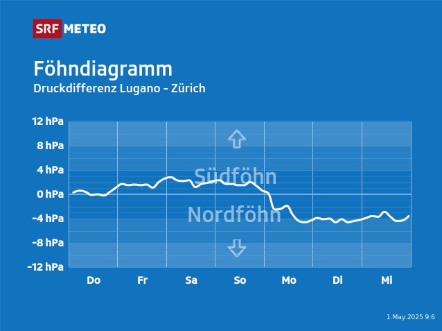
Pressure distribution Switzerland

- From 0 hPa (solid line) upwards is south foehn, always a very good sign for wind. The higher the curve the stronger and gustier the wind can get.
- Between 0 and -4 hPa there is a north foehn, but it is often too weak to affect the valley, especially if the sun is shining. The much stronger Maloja wind will then sooner or later break through and dominate.
- From -4 to -6 hPa we have north foehn and the chance of Maloja wind is smaller, but still present if all other boxes are ticked.
- Below -6 hPa the north foehn is normally too strong and only rarely does the Maloja wind break through.

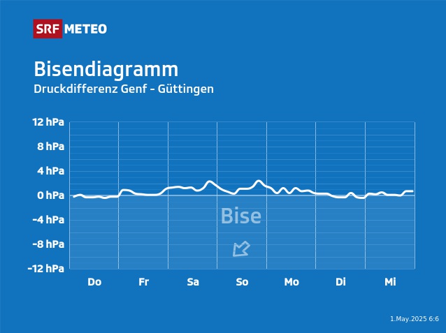
Below -2 hPa the bise is blowing and can hinder the thermic winds.
Maloja Wind
The Maloja wind is an unusual wind that actually blows in the wrong direction. Remember, in school they used to say: "the valley wind blows up the valley during the day and the mountain wind blows down the valley at night". With the Maloja wind it is exactly the opposite, instead of blowing up the valley, it blows down the valley during the day. The reason for this is the topography. The Upper Engadin, which is over 50 km long, descends only about 350 meters from Maloja to Zernez. The Bergell, on the other hand, rises from Chiavenna to Maloja from 300 to 1800 meters above sea level over a distance of 20 kilometers.
The sunny terrain of the Bergell heats up quickly in the morning, causing the air to rise and creating a small low-pressure system over the rock faces of the Maloja Pass. This causes the wind to rise and start blowing up the valley. As the valley floor on the Engadin heats up, a wind starts blowing uphill and this additionally sucks in the air flow from the Bergell. The warmer it gets in the Bergell, the stronger the wind becomes.
On typical Maloja wind days there are between 4 and 5 Beaufort with peaks around 6 Beaufort on lake Silvaplana. This is equivalent to wind speeds of almost 50 kilometers per hour. Usually the wind picks up shortly before midday and then rapidly increases in strength. It is only from the late afternoon when the sun drops behind the mountains that the wind gradually loses its power. Like almost all thermal wind systems, the wind is extremely susceptible to "disturbances". There are many different types of disturbances and they can have a weakening or strengthening effect on the wind. For example, the updraft of clouds or northerly to south-easterly air currents are considered to weaken the wind. However, the wind is often strengthened up to 6 to 7 Beaufort when there are strong westerly to southwesterly currents passing over the mountains.
The Upper Engadin also has a wind blowing up the valley called "Brüscha". This is actually the wind that we all learned about in school. However, because of the small difference in altitude from Zernez to Maloja, it is more of a gentle breeze than a wind and therefore has no chance against the strong Maloja wind blowing down the valley.

